As part of the Rundle Street Movement Study the Department has collected detailed movement data, including crash records, pedestrian and cyclist counts, traffic speeds and volumes, intersection turning movements, parking demand and video observations. The findings show several consistent issues:
- Crossing the road is difficult, with high pedestrian demand but limited safe crossing points.
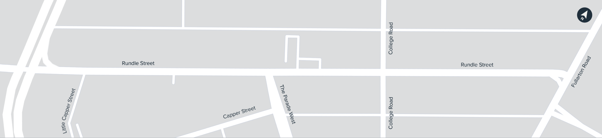
- Cyclist safety is a major concern, particularly at The Parade West, which has a history of cyclist crashes.
- Traffic volumes and turning movements create delays and make it harder for people to move safely.
- Parking demand often exceeds supply, with some vehicles overstaying time limits.
- Sightlines at key driveways are limited, creating conflict between vehicles, people walking and people riding.
At the same time, Kent Town’s population is growing, and its demographic profile is changing—with more residents choosing apartment living, fewer cars per household, and a higher proportion of people walking and riding as a form of transport. As the area becomes busier and more residential, it’s increasingly important that the street is designed to safely support more people moving in more ways.
This study helps identify where improvements are needed now, while also planning for the future so the street continues to function well as the community grows and changes. Your feedback will help shape upgrades such as safer crossings, better cycling facilities, lower traffic speeds, improved driveway safety and more accessible connections.
Engagement is now underway with the community, stakeholders and Council to share these findings and work together on shaping future improvements for the street.
Proposed Interventions
The Department for Infrastructure and Transport is exploring a range of upgrades to make Rundle Street safer, more accessible, and easier for people to move along—whether walking, riding, catching public transport, or driving. Below is a simple overview of what’s being considered and why. There is currently no funding for the construction of these upgrades, your feedback will help to inform the outcomes of the study.
Crossing the road is difficult, with high pedestrian demand but limited safe crossing points.
- We conducted full‑day pedestrian counts, which showed that more than 1,800 people cross
edRundle Street on a weekday. Many chose to cross at locations with no safe facility, especially near The Parade West and College Road. - We mapped all existing crossing points and confirmed that apart from Dequetteville Terrace, there is a lack of priority crossings anywhere in this section of Rundle Street.
- Long distances between informal refuges make it hard for people to find safe gaps on this busy, high‑traffic corridor.
Cyclist safety is a major concern—especially at The Parade West, a known crash location.
- A five‑year crash review identified 12 cyclist crashes and nine injuries at the Rundle Street / The Parade West junction — making it a cyclist Black Spot.
- Video footage showed drivers encroaching into bike lanes, taking risky right turns, and struggling to find safe gaps in traffic.
- Existing bicycle lanes are narrow, part‑time in places, and do not meet design requirements for a strategic link in the metropolitan cycling network.
Traffic volumes and turning movements create delays and make movement less safe
- Seven‑day traffic counts revealed over 12,000 vehicles per day between Dequetteville Terrace and The Parade West — much of it through‑traffic headed to/from the CBD.
- Intersection surveys showed long queues for right turns, especially at The Parade West, where queues reached 18 vehicles during the morning peak.
- Drivers often accepted unsafe gaps due to long delay times, contributing to crash risk.
Parking demand exceeds supply, with many vehicles overstaying
- Parking surveys showed that on weekdays, several sections operated at over 100% occupancy (due to overstaying and illegal parking).
- Data suggests some spaces are used for long stay parking, reducing turnover and limiting access for customers and short‑stay users.
- Pressure is highest near intersections, businesses, and the Bunnings driveway.
Sightlines at key driveways are limited, creating conflict between vehicles, people walking and people riding
- Field observations and video captured vehicles creeping into the bike lane at the Bunnings driveway while trying to see oncoming traffic.
- The driveway experiences very high volumes — almost 1,900 vehicle movements over 11 hours — making it function more like a side street.
- Parked cars and steep verge grades reduce visibility for both drivers and cyclists.
Crossing the road is difficult, with high pedestrian demand but limited safe crossing points.
- New Wombat Crossings - raised pedestrian crossings slow traffic and give people walking legal priority. They are proposed at areas with the strongest pedestrian desire lines, particularly around College Road.
- Replace existing refuge with a Wombat Crossing (west end) - this treats one of the busiest crossing points with a higher‑safety design.
- Safer speed limit - lowering speeds to 40 km/h supports safer crossing everywhere, not just at crossing points.
Cyclist safety is a major concern—especially at The Parade West, a known crash location.
- Traffic signals at Rundle Street/The Parade West -this treatment would control movements to mitigate right-turn conflict and provide pedestrian crosswalks across all street legs.
- Green bike lanes and improved sight distance - high‑visibility surface markings reinforce cyclist presence at the Bunnings driveway and other conflict points, paired with removing a small number of car parks to open up sightlines.
- These upgrades work together to reduce crash risk and create safer, more predictable movements.
Traffic volumes and turning movements create delays and make movement less safe
Traffic signals -
- Control turning movements.
- Reduce risky gap‑acceptance.
- Improve safety for people walking and riding.
- Support smoother, more predictable traffic flow.
Safer speed limit -
- Reduces the severity of crashes.
- Makes crossing and driveway movements safer.
- Creates a calmer, more appropriate environment
- for a mixed‑use street.
Parking demand exceeds supply, with many vehicles overstaying
Recommendation for Council to adopt a contemporary parking strategy to:
- Prioritise short‑stay use.
- Improve enforcement.
- Consider smart‑parking tools.
- Ensure available parking is used more efficiently.
Sightlines at key driveways are limited, creating conflict between vehicles, people walking and people riding
- Improved sight distance - remove two parking spaces on each side of the driveway, as is standard at side streets, to give drivers and cyclists clear lines of sight.
- Green bike lane treatment - draws driver attention to the presence of cyclists and clarifies priority through the driveway.
Wombat crossings
- Some on‑street parking spaces must be removed near each crossing for safe sightlines.
- Drivers may experience slower travel speeds and may need to stop more frequently however the increase in overall travel time increase would be minimal.
Traffic signals
- Loss of on-street parking spaces to fit signal hardware, turning bays and safe sightlines.
- Slight queue increases at peak times (to be managed through modelling and signal timing).
Slower speed limit
- Slightly slower travel along the corridor with a 40 km/h speed limit, however the overall travel time increase would be minimal.
Driveway and sight line improvements
- Drivers will need to slow down and give way more consistently, which may feel less convenient than the current “creeping forward” behaviour.
- Slight reduction in kerbside parking availability near high‑volume driveways such as Bunnings.
- More cautious driving behaviour required, which may change how drivers enter and exit the driveway


